


Manang - Upper Pisang reel

perlimpinpin59
User GUIDE
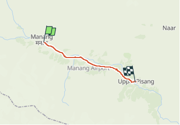

Length
16.6 km

Max alt
3519 m

Uphill gradient
284 m
Km-Effort
21 km

Min alt
3201 m

Downhill gradient
498 m
Boucle
No
Creation date :
2025-04-23 01:56:18.0
Updated on :
2025-04-23 09:57:48.906
8h00
Difficulty : Very difficult

FREE GPS app for hiking
 SityTrail
IGN / Geographical institutes
SityTrail Plus
The world is yours!
About
Trail Walking of 16.6 km to be discovered at Unknown, Manang, Tanki Manang. This trail is proposed by perlimpinpin59.
Positioning
Country:
Nepal
Region :
Unknown
Department/Province :
Manang
Municipality :
Tanki Manang
Location:
Unknown
Start:(Dec)
Start:(UTM)
209372 ; 3174346 (45R) N.
Comments